Martis Peak Fire Lookout

The fire lookout on Martis Peak can be reached from both Martis Peak Road and the Tahoe Rim Trail. We had a limited amount of time, so we opted to go up the paved road which is a slightly shorter route. This hike is 8 miles roundtrip, with about 1700-ft of elevation gain.

00

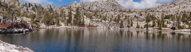
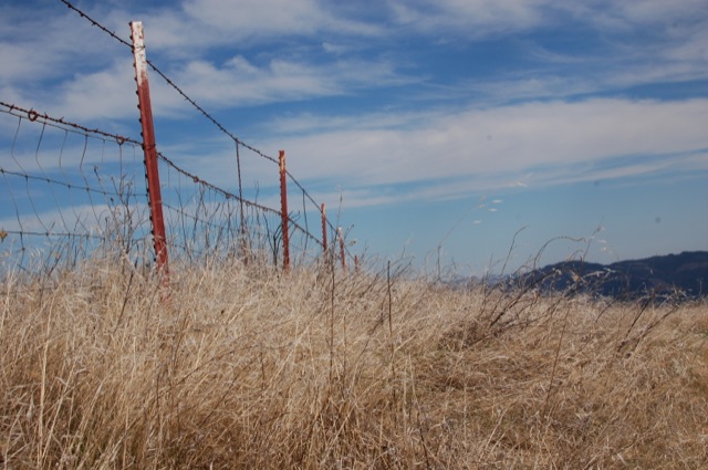
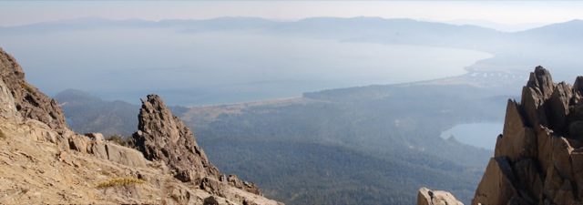
It’s been way too long since we got out and hit the trails.  We had some spare time before the holidays, so we decided to head up to Tahoe for the weekend.  There’s not much snow yet this year – 2013 was the driest calendar year on record (though water is usually summed by water year: Oct-Sep).  California is going to have some serious water problems if we don’t get crazy amounts of rain/snow in the next couple of months.  We wanted to use our snowshoes, but the road looked pretty bare so we left them in the car.  (Of course the road was completely covered in snow as soon as we turned the first corner.)  This hike was 8 miles roundtrip, with about 1700-ft of elevation gain. Continue reading “Martis Peak Fire Lookout”

Ropi Lake via Horsetail Falls – Desolation Wilderness

This hike is 6-ish difficult miles beginning at the Pyramid Creek trailhead on Highway 50, with about 1900 feet of elevation gain. The unmaintained trail goes past Horsetail Falls (a neat destination itself) up to several beautiful lakes in Desolation Wilderness.

00

I’ve been wanting to hike up Pyramid Peak for quite some time, but it just hasn’t happened (yet). On the occasions I have planned to do this hike, I’ve been stopped by major thunderstorms or crazy gusts of wind. This weekend, the weather was looking pretty perfect, but with a late start and the days already getting shorter, we didn’t make it up the peak. I will get there eventually.  Instead, we hiked up to some high alpine lakes and enjoyed a beautiful and relaxing October day in Desolation Wilderness. Continue reading “Ropi Lake via Horsetail Falls – Desolation Wilderness”

Jack London State Park – Mountain Trail

We hiked the Mountain Trail towards the top of Sonoma Mountain – a seven mile hike with over 1500 ft of elevation gain. It doesn’t quite reach the top which is outside of the park boundary, but it’s nonetheless a great hike.

00

It has been far too long since we’ve had a chance to get out and hike.  Work and other commitments have taken up way too much of our time.  We have plans to go to Yosemite in a few weeks – let’s hope the government is back up and running by then.

While visiting friends and family in Sonoma County last weekend, we made plans to stop at Jack London State Park.  We hiked the Mountain Trail towards the top of Sonoma Mountain – a seven mile hike with over 1500 ft of elevation gain.  It doesn’t quite reach the top which is outside of the park boundary, but it’s nonetheless a great hike. Continue reading “Jack London State Park – Mountain Trail”

Mount Tallac in Desolation Wilderness

00

Basics:  Mount Tallac is a 10 mile hike (out and back) with approximately 3500 ft of elevation gain.  The main trailhead is just a few miles west of South Lake Tahoe, though this peak can also be reached from Gilmore Lake and other areas deeper in Desolation Wilderness.  It’s strenuous, but the incredible views down to Fallen Leaf Lake, Lake Tahoe, and over to Desolation Wilderness make this a very popular hike.  On summer weekends, there can easily be dozens of people on the summit at once.  I would recommend an early start.  Permits for day hikes are self-issued at the trailhead.  For overnight trips, reserve your permit in advance at Recreation.gov. Continue reading “Mount Tallac in Desolation Wilderness”

Mariposa Grove to Wawona

00

Basics: This 6 mile trail near Yosemite’s southern entrance connects the Wawona Hotel to the Mariposa Grove of Giant Sequoias. From mid-spring until the first snowfall, a free shuttle bus runs between these two locations, so this hike can easily be done one-way only. Alternatively, one could hike out and back for a total of 12 miles. The loops around Mariposa Grove are several miles long- so this could potentially make for a very high mileage day. It’s all uphill from the Wawona Hotel to the grove, so naturally we decided to be lazy take the shuttle to the grove, then walk downhill back to the hotel. Continue reading “Mariposa Grove to Wawona”

Garrapata State Park Loop

01

Basics: This 4+ mile loop trail in Garrapata SP goes from coastal chaparral to grassy hills with epic views to dense redwood forest.  Parts of the trail are really steep, but the ocean views and springtime wildflowers are enough to keep anyone going.  We added a side trip to Doud Peak, making this a 6 or 7 mile hike.  Doud Peak was not worth the extra effort, but more on that later.  This hike would be nice any time of year, but it’s especially pretty in the spring when the plants are still somewhat green and the wildflowers are blooming.  It’s also a great workout if you are in the area and want to hike something that won’t take all day. Continue reading “Garrapata State Park Loop”

Castle Peak – Tahoe National Forest

Basics: Castle Peak (9104′) is a prominent mountain close to Donner Pass on I-80. It’s a popular destination for summer hiking and winter snowshoeing or backcountry skiing. The summit is about 3 miles (and 1800′) from the trailhead. In the winter, much of the trail is well graded and easy to follow. The last half mile or so up to the summit is pretty steep. Most people we saw were using snowshoes, but if conditions were really icy, crampons and an ice axe might be a bit easier. Continue reading “Castle Peak – Tahoe National Forest”

Channel Islands – Santa Cruz Island Backcountry

Basics: This trip is an easy beginners backpacking trip on Santa Cruz Island at Channel Islands NP. The trickiest part is getting a campsite reservation, arranging transportation to and from the island, and packing in your water. This hike could be anywhere from 7 to 20+ miles round trip, depending on where you get off the boat. We hiked 3.5 miles to the backcountry campsite, and took a longer 5 mile route back out. Continue reading “Channel Islands – Santa Cruz Island Backcountry”

Hood Mountain & Gunsight Rock

Basics: This hike takes you up over the top of Hood Mountain to an overlook called Gunsight Rock. On a clear day, the overlook provides sweeping views of the Sonoma Valley. There are multiple trails in Hood Mountain Regional Park – this trip can be anywhere from 6 to 8+ miles depending on your route. Parking is $6 and maps are provided at the trailhead. Dogs are allowed on all the trails. Continue reading “Hood Mountain & Gunsight Rock”

Ralston Peak – Desolation Wilderness

Basics: Ralston Peak is located in the southern part of Desolation Wilderness and is relatively easy to reach.  There is a trailhead with parking on the north side of Hwy 50 at Camp Sacramento.  Permits are required.  The hike is just under 6 miles (roundtrip) and involves a moderately strenuous gain of about 2700-ft. Continue reading “Ralston Peak – Desolation Wilderness”